
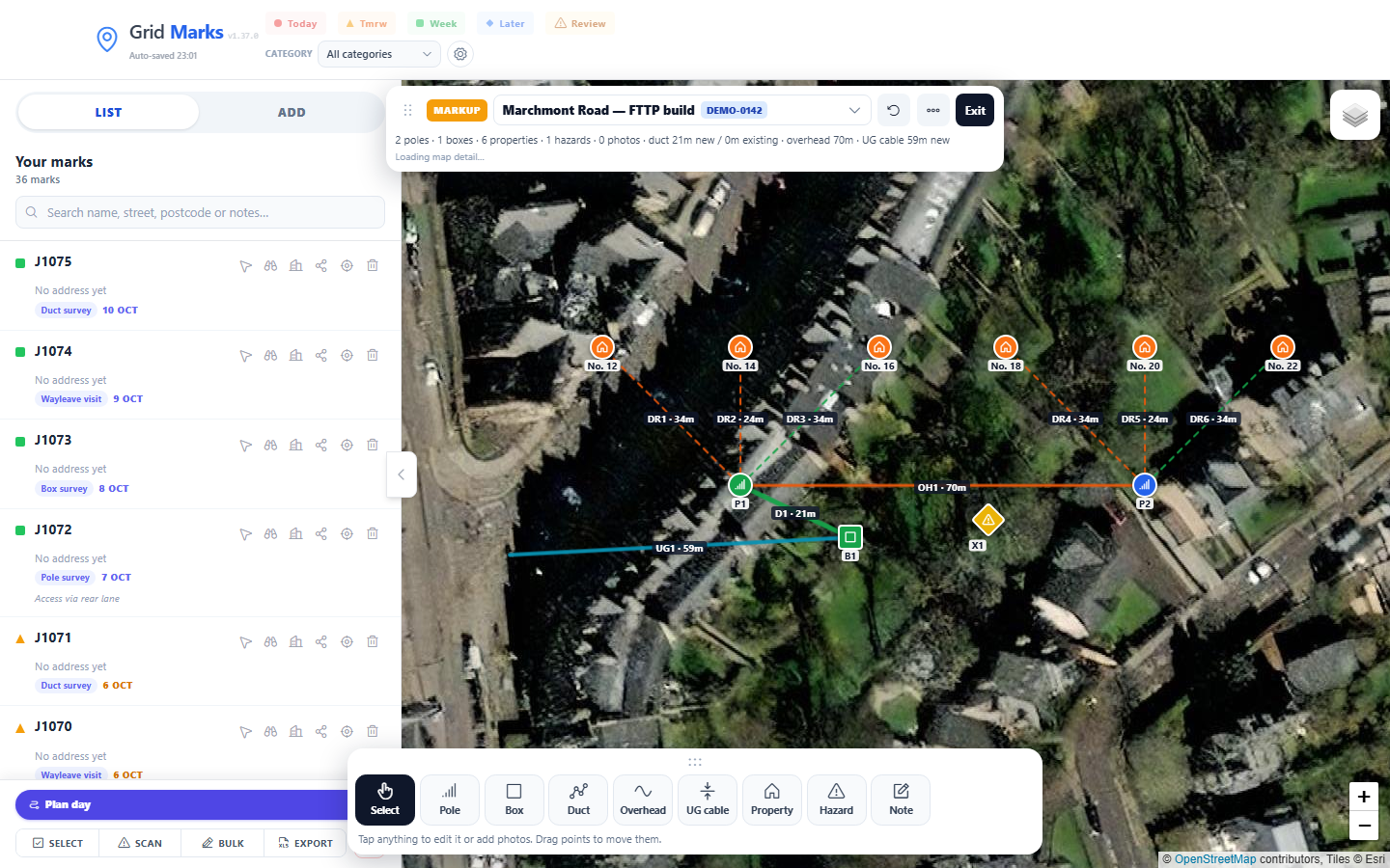


Mark up the design on site
Sketch poles, boxes, duct, overhead and underground cable and drops to each property over satellite mapping, down to building level. Add hazards by utility, notes and photos to anything.
Built for UK field surveyors
Import sites from OS grid reference, easting/northing, postcode or Excel, colour them by due date, plan the day’s route, sketch the design on site, and keep working with offline council maps — free, no login. Grid Marks is a survey mapping tool for planning and marking locations across the UK.
Free forever for everyday use. No login. Data stays on your device. Install to the home screen for field storage protection on iPhone.
Built around real field workflow — not a generic pin app.
Sketch poles, boxes, duct, overhead and underground cable and drops to each property over satellite mapping, down to building level. Add hazards by utility, notes and photos to anything.
Export a presentation PDF with enlarged detail pages where it’s busy, an Excel workbook with schedules and photos, a picture, or GeoJSON — and send the GeoJSON to a colleague to open the same design.
Due-date colours (today / tomorrow / week / later), categories you define, list search, relocate, share links, and Street View from the pin — tap a street on its mini map to look from there.
Import Excel or CSV job lists. Auto-detect per row reads mixed OS grid references, easting/northing, lat/lng and addresses with a postcode in the same file. Exports from other systems work as they are — any tab, title rows and all. Excel import guide.
Download whole council areas for street-level maps with no signal. Save a small aerial patch of today’s work area when you need it.
Order stops for the route, see times and distances, export or print. Built for getting around sites efficiently.
Open free public search for Scotland (ScotLIS map), England & Wales (HMLR), and Northern Ireland guidance — right from the pin.
Import historical work and see nearby records when you open a mark — useful context before you knock on the door.
No account and no server copy: marks, designs and photos live in your browser. Export a project or design file whenever you want a backup or to hand work on.
Whether you plan routes from a desk or need a map with no signal on site.
Add marks from OS grid references or easting and northing, then see them on a UK map with Street View and directions when you need them.
Keep inspections, utility strikes, pipeline markers and joint meetings organised with categories and due-date colours — not a pile of sticky notes.
Walk the route and mark up what’s needed — new or existing poles and boxes, duct and cable runs, the drop to each house, hazards to check — then hand over a PDF or Excel pack the same day.
Download street maps for a whole local authority before you leave. Works as a progressive web app so your marks stay on the device.
Import a job list — even when rows mix grid refs and other coordinate styles — then plan the day and share links. Excel import & auto-detect guide.
Record hazards by utility with owner and depth, note when the LSBUD search and plans are done, and open LSBUD from a pin with the easting and northing ready to paste.
No account setup. Open the app and start mapping.
Drop a pin from search, GPS, grid ref, or import your job list from a spreadsheet.
Filter by due date or category, plan the route, and download offline maps for areas with poor signal.
Open Street View, mark up the design with photos, check land register search, then export the design pack and save the project when you’re done.
We’re focused on growing a tool surveyors actually use in the field. Paid plans may come later for heavy power features — everyday mapping stays free.
£0 No account required
Coming later Optional, when it earns its keep
Nothing locked behind a wall today. You’ll hear about paid options when they’re ready — not before.
Your marks are stored on your device (and in project files you export). Install to the home screen on iPhone so Safari doesn’t clear storage after a week of inactivity.
Two mailboxes so enquiries and product feedback stay organised.
Acceptable use: free for legitimate survey and mapping work. Please don’t scrape, clone, or resell Grid Marks as your own product. Full details in our Terms of use.
Open Grid Marks in your browser — desktop or phone — and start marking in seconds.
Launch Grid Marks