
About · Guide
Import survey jobs from Excel to a map
Most survey and site-visit work arrives as a messy spreadsheet, not as a clean pin list. Grid Marks imports Excel or CSV and places each row on a UK map — and its stand-out option is Auto-detect per row (mixed formats): one file can mix OS grid references, easting/northing and lat/lng without you reformatting every line. Free, no login.
Stand-out feature
Auto-detect location per row
Most map tools make you pick one coordinate format for the whole sheet.
Real job packs are mixed: some rows are TQ 308 805, others are separate easting/northing,
others lat/lng, and sometimes a grid ref is buried in a notes cell.
In the column mapper, set Coordinate format in your file to Auto-detect per row (mixed formats). Tick the location columns to scan (in priority order). For each row, Grid Marks tries those columns until it finds a readable location — first match wins. That is rare outside specialist GIS and is built for how survey files actually look.
Quick steps
- Open gridmarks.co.uk — phone or desktop. No account.
-
Add & import → Import spreadsheet
— choose
.xlsx,.xlsor.csv. -
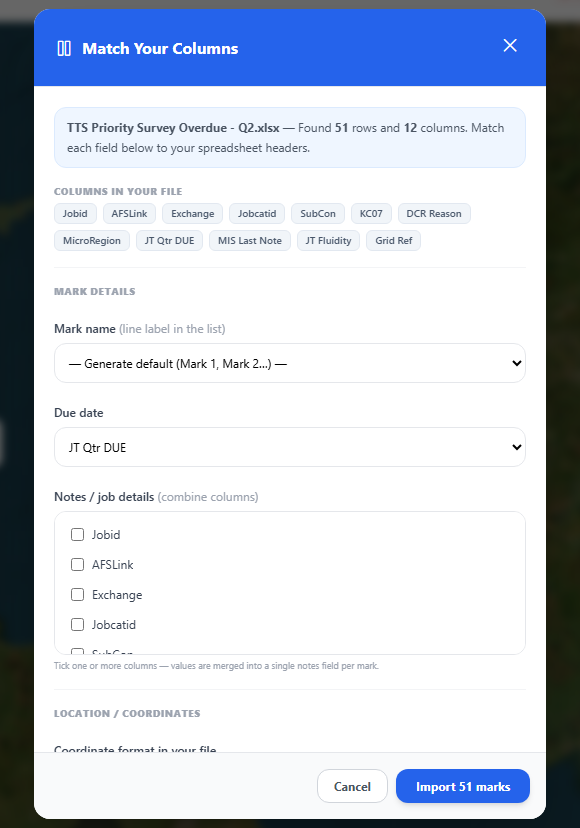
Match columns in the mapper:
- Name — site / job title (or use a default mark name)
- Due date — optional; drives today / tomorrow / week colours
- Category — optional (inspections, utility strikes, etc.)
- Details / notes — optional extra columns combined into notes
- Coordinate format — leave on Auto-detect per row for mixed files
- Location columns to scan — tick every column that might hold a position (order = priority)
- Check the preview, then Import marks. Pins appear on the map; the list updates to match.
- Next: filter by due date, use Plan Day, export, or download offline maps for the councils you will visit.
Tip: If the file was previously exported from Grid Marks, columns are often pre-detected — including paired Easting/Northing or Latitude/Longitude. Still confirm auto-detect columns before a large import.
What auto-detect can read (per row)
Under auto-detect, each row is scanned independently. You do not have to force the whole spreadsheet into a single format first.
OS grid reference
e.g. TQ 308 805 or TQ308805 in its own column or inside a longer text cell.
Easting & northing
Separate columns, or both numbers in one cell. British National Grid metres — common in asset exports.
Latitude & longitude
WGS84 decimals, as two columns or a combined pair. Useful when data already came from GPS.
Coords in free text
Flexible parsing for values embedded in notes or “location” fields — not only tidy pure columns.
Prefer a fixed format for a clean file? You can still choose Easting & Northing only, OS Grid Reference only, or Lat/Lng only. Auto-detect is the advanced path when the sheet is mixed. For one-off pins, see how to plot an OS grid reference.
Why this matters on real jobs
- No pre-cleanup marathon — keep the supplier or back-office format as-is.
- Merged lists — combine routes that used different coordinate styles in one import.
- GridMarks re-imports — separate E/N or lat/lng columns from a previous export are handled in auto scan order.
- Fewer skipped rows — more chance each line finds a usable location without hand edits.
Prepare a clean job list (optional but faster)
- Put headers in row 1 with clear names (Site, Due, Easting, Northing, Grid ref, Notes…).
- Keep one row per visit or asset.
- Use a consistent date format where possible (or leave due date blank and set later).
- Remove empty junk sheets if the file is multi-sheet — the first sheet is used.
- Very large files: stay under about 20 MB, or split the spreadsheet.
After import: organise the day
- Due-date chips — show only today / tomorrow / this week if the sheet had dates.
- Categories — filter inspections vs utility work vs general marks.
- Plan Day — order stops and export or print a route list.
- Offline maps — download the local authority basemap before you lose signal.
- Export — save an updated spreadsheet or project file when the day is done.
Frequently asked questions
What file types work?
.xlsx, .xls and .csv. UTF-8 CSV is safest for special characters in street names.
My columns have odd names — will it still work?
Yes. The column mapper lets you pick any header for each field. Suggestions appear when names look familiar (easting, grid, due date, etc.), but you stay in control. Auto-detect only looks at the location columns you tick.
Can one spreadsheet mix grid refs and lat/lng?
Yes — that is exactly what Auto-detect per row is for. Tick every column that might hold a location; each row uses the first format it can parse successfully.
Some rows are skipped — why?
Rows need a usable location after scanning. Blank cells, invalid grid refs, or points far outside the UK may be skipped. Add more scan columns, fix the sheet, re-import, or add those sites manually.
Is bulk import free?
Yes for everyday use — no login and no paywall today. See the free plan summary.
Where is the data stored?
Marks stay on your device (and in project or Excel files you export). Install to the home screen on iPhone so storage is less likely to be cleared after inactivity.